27. Map#
Lists tell you what belongs to a trip. The map tells you where it is — and whether the accommodation on day three really is next to the hike or two hours away. The Map section lays all the places of a trip on top of each other: accommodations, activities, outdoor activities, journeys, and journal entries.
27.1 All the places of a trip on one map#
You reach it through the trip, not through the tab bar: open the trip, then tap Map in the section grid. The trip overview also has a small map preview; its footer names the number of places and leads with Map into the large view.
Only what has coordinates makes it onto the map. An entry with a place name but no coordinates stays invisible. If the trip has nothing georeferenced at all yet, you see No geodata with a note that entries appear as soon as they have coordinates.
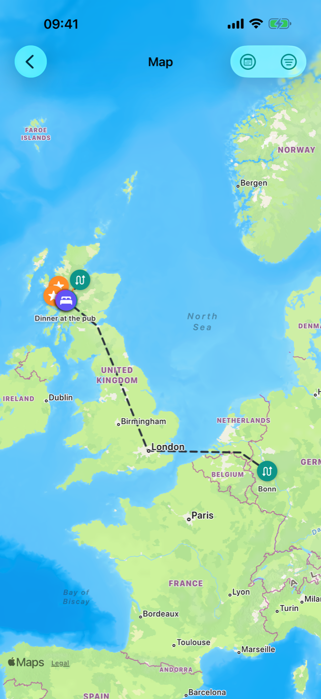
Besides the points, Etappe draws lines:
| Line | Meaning |
|---|---|
| dashed, charcoal | planned journey from the start via the waypoints to the destination |
| dashed, blue | journey with ferry as the mode of transport |
| dashed, yellow, as an arc | flight without a drawn route |
| solid, orange | recorded actual route of a journey |
| solid, charcoal | GPX track of an outdoor activity entry |
A journey line only appears when start and destination have coordinates; the waypoints in between bend it into shape (Journeys). Flights without waypoints of their own are drawn as an arc, as you know it from flight maps. If you have applied a recording as the definitive route, the dashed draft of that journey disappears and only the orange line remains (Recording a journey).
27.2 Marker types and filters#
Each pin is a colored circle with the symbol of its type. The name of the entry sits above the pin.
| Type | Color | Symbol | What it includes |
|---|---|---|---|
| Accommodations | Indigo | Bed | accommodations with coordinates |
| Activities | Orange | Star | activities with coordinates |
| Outdoor activities | Green | Hiker | starting point from the form or from the GPX track |
| Journeys | Teal | Double arrow | one pin each for the start and destination of every journey, labeled with the place name (or the journey name as a fallback) |
| Journal | Purple | Book | entries with a place |
At the top right sits Filter. The popover lists the five types; a tap turns a type on or off, the checkmark on the right shows the state. Once not all types are active, the filter symbol appears filled — so you can see at a glance that the map is currently not showing everything.
The filter applies to pins and lines: without Journeys, journey lines and recordings disappear too; without Outdoor activities, so do the GPX tracks. If you turn off all types, the map stays empty — the “No geodata” note does not appear then, because the data is there after all.
27.3 Filtering by trip day#
If the trip has a period, Day filter also sits at the top right. Turned on, it shows a bar at the bottom: Day X of Y on the left, weekday and date on the right, below them a slider (for trips of more than one day). This way you walk through the trip day by day and see only what is on for that day.
What counts as “on that day”:
| Entry | Applies on the day if |
|---|---|
| Accommodation | the day lies between check-in and check-out |
| Activity | the day lies within the from/to period |
| Journey | start pin and line: the day lies between departure and arrival; destination pin: only on the day of arrival |
| Outdoor activity | the date of the entry matches |
| Journal | the date of the entry matches |
| Recorded route | the day lies between the start and end of the recording |
Important: Entries without a date are hidden while the day filter is active. If you are missing something on the map, the date is usually empty — or the day filter is still on. Turn it off again with the same symbol, and the map shows the whole period again.
27.4 Tapping a pin and jumping to the entry#
A tap on a pin opens a half-height info sheet. At the top are symbol, name, type and the period — a single date such as “Thu, 06/12” or a range if start and end fall on different days.
For accommodations, the contact rows are added, provided they have been entered:
- Address — a tap starts navigation in your chosen route planner; the symbol on the right copies the address to the clipboard.
- Phone — a tap dials the campground’s number.
- Website — a tap opens it in the browser.
If the accommodation is a campground with recorded amenities, the features appear below as chips (Accommodations).
At the very bottom, Open details leads straight into the entry — depending on the type, into the detail of the accommodation, activity, outdoor activity entry, journey or journal entry. You get back as usual via the back navigation.
27.5 Zooming, panning, map section#
The map responds to the familiar gestures: pan with one finger, zoom and rotate with two fingers, double-tap to zoom in. The long press is taken (see 27.6 New entry by long press) — short taps on the pins and all map gestures are unaffected by it.
Etappe sets the initial section itself when the map opens: it covers all visible points including the start and end of the lines, with some margin. The home location only helps span the section if the trip has fewer than two points of its own — otherwise a distant destination would force half the world map. After that you control the map freely; if you leave the map and come back, the calculated section is set again.
27.6 New entry by long press#
Standing in front of a place you want to remember? Hold your finger on the map for about half a second. New entry opens with three sections:
- What — a choice between Accommodation, Activity and Journal (Activity is preselected).
- When — the date. Preset to the currently selected day if the day filter is running, otherwise to the start of the trip.
- Place — the coordinates you hit, for checking.
Next opens the matching form, already filled with place and date; you just add the name and details and save. Cancel discards everything. If your trial has expired, the note about the full version appears instead of the dialog (Trial and full version).
27.7 The house: your home location#
If a home location is set, the map shows it as a white house on a green circle, labeled “Home”. It belongs to no trip and therefore cannot be hidden with the type filter or the day filter — it is always the fixed reference point.
You set it in Settings under Home with Choose home location: tap the point on the map or use Current location, then Apply. Remove home location deletes it again. With iCloud, the setting applies on all your devices; without iCloud only on this one (Home, All settings).